Weekly digest
Pick the categories you care about: movies, AI launches, sports, eclipses, and major public dates. One email per week, and never anything you did not ask for.
Want full preferences? Customize your digest →
MZG · Huxi, Taiwan
--:--:-- · GMT+8 (UTC+08:00) · 23.5687° N, 119.6280° E
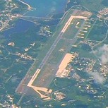
Penghu Airport
Domestic airport in Huxi, Taiwan
Verification trail
This section separates stable airport identifiers from live operating data. Codes, coordinates, timezone, elevation, source identifiers, and accepted reference links are retained here; live arrivals, departures, gates, delays, NOTAMs, and airline schedule changes must still be checked with the airport or carrier.
OurAirports ID 5524; ident RCQC; scheduled service listed.
Cached airports.csv snapshot: 2026-04-25; runways.csv snapshot: 2026-05-21.
mkport.gov.tw
Used as the preferred live-reference handoff for terminals, gates, alerts, and airport notices.
Open sourcePenghu Airport
Airport-shaped reference summary from en.wikipedia.org; summary snapshot 2026-05-25.
Open source20 source-backed signals
Merged from OurAirports cached airports.csv, OurAirports cached runways.csv, Wikidata airport entity snapshot, airport-shaped Wikipedia summary snapshot; facts generated 2026-05-25.
IATA / ICAO
MZG / RCQC
OurAirports ident
RCQC
GPS / local code
RCQC
ISO region
TW-PEN
Scheduled service
Listed in source snapshot
Role
large scheduled-service airport
Official host
mkport.gov.tw
Reference host
en.wikipedia.org
Wikidata entity
Q708281
Snapshot generated
2026-05-25
Airport lookup keys
Stable codes
Regional keys
Alternate names
Nearby airport codes
Route reference codes
Accepted citation URLs
Last updated May 25, 2026. Stable airport identifiers and timezone facts are content-reviewed; clocks render live in the browser, while weather and time-difference notes are page-snapshot aids rather than permanent airport records.
Live values rendered at Jun 2, 6:06 PM UTC.
Local airport time
--:--:--GMT+8 · UTC+08:00
Time zone
GMT+8
Asia/Taipei · UTC+08:00
Airfield conditions
Live airport weather is temporarily unavailable.
Surface access
88 km
Approximate distance to central Huxi.
Country capital
Taipei
Languages
Chinese
Currency
TWD ($)
Country area
36,197 km²
Passenger volume
2,380,265 passengers (2017)
Terminals
Not clearly stated
Runways
1 runway
Longest runway
9,843 ft / 3,000 m
Runway surface
concrete
Opened / operator
1977 · Civil Aeronautics Administration
Owner / entity
Q708281
Hub airlines
Mixed or not clearly stated
Airport role
large scheduled-service airport
Scheduled service
Listed
Fact coverage
20 source-backed signals
Penghu Magong Airport is a large scheduled-service airport for Huxi, Taiwan. Huxi's built-up core sits roughly 88 km from the terminal area. Operations run on Asia/Taipei (UTC+08:00, GMT+8). Live weather is temporarily unavailable. With 5 other indexable airports in its surrounding network, it works well as a reference point for regional flight planning and timezone checks.
Penghu Magong Airport (MZG / RCQC) is at 23.5687° N, 119.6280° E, elevation 103 ft (31 m), serving Huxi, Taiwan.
The accepted reference summary is used as supporting context for the airport identity and operating notes; the timed facts here still come from the airport catalog, timezone database, country snapshot, and linked source trail.
Huxi is in Taiwan (capital Taipei); on Asia/Taipei (GMT+8, UTC+08:00); working languages: Chinese; currency: TWD ($).
Distance from central Huxi: 88 km.
A compact traveler-facing brief from the airport catalog, country snapshot, route geometry, city anchors, peer airports, and source trail for MZG.
Primary airport name
Penghu Magong Airport (MZG / RCQC)
Penghu Airport · Domestic airport in Huxi, Taiwan
Known label 1
Magong
Alternate airport-name cue retained for MZG, not a separate indexable duplicate page.
Known label 2
Makung
Alternate airport-name cue retained for MZG, not a separate indexable duplicate page.
Source identifiers
RCQC · RCQC · TW-PEN
mkport.gov.tw · en.wikipedia.org · scheduled service yes
Regional role cue
Handling 2,380,265 passengers in 2017, it is the fifth-busiest airport in Taiwan.
Accepted from the airport reference trail as a role-specific cue for MZG; not treated as a live service guarantee.
1. Magong
magong · 4.3 km from MZG
Taiwan · Asia/Taipei · +0h · population 63,745 · city coordinates 23.5654, 119.5863
2. Budai
budai · 58 km from MZG
Taiwan · Asia/Taipei · +0h · population 19,268 · city coordinates 23.3779, 120.1615
3. Beigang
beigang · 69 km from MZG
Taiwan · Asia/Taipei · +0h · population 33,300 · city coordinates 23.5701, 120.3016
4. Taibao
taibao · 73 km from MZG
Taiwan · Asia/Taipei · +0h · population 38,696 · city coordinates 23.4594, 120.3322
5. Xingang
xingang · 73 km from MZG
Taiwan · Asia/Taipei · +0h · population 30,543 · city coordinates 23.5574, 120.3460
6. Xinying
xinying · 75 km from MZG
Taiwan · Asia/Taipei · +0h · population 74,972 · city coordinates 23.3069, 120.3106
1. RMQ RCMQ
Taichung International Airport / Ching Chuang Kang Air Base · Taichung (Qingshui)
127 km from MZG · Asia/Taipei · +0h · elevation 663 ft (202 m) · airport coordinates 24.2647, 120.6210
2. KHH RCKH
Kaohsiung International Airport · Kaohsiung (Xiaogang)
133 km from MZG · Asia/Taipei · +0h · elevation 31 ft (9 m) · airport coordinates 22.5771, 120.3500
3. XMN ZSAM
Xiamen Gaoqi International Airport · Xiamen
187 km from MZG · Asia/Shanghai · +0h · elevation 59 ft (18 m) · airport coordinates 24.5439, 118.1275
4. HUN RCYU
Hualien Chiashan Airport · Hualien City
209 km from MZG · Asia/Taipei · +0h · elevation 52 ft (16 m) · airport coordinates 24.0232, 121.6180
5. TPE RCTP
Taiwan Taoyuan International Airport · Taoyuan
234 km from MZG · Asia/Taipei · +0h · elevation 106 ft (32 m) · airport coordinates 25.0777, 121.2330
1. MZG-RMQ
Taichung (Qingshui) · 127 km · 1h 0m
Asia/Taipei · +0h from MZG; reference route only, not a live schedule.
2. MZG-KHH
Kaohsiung (Xiaogang) · 133 km · 1h 0m
Asia/Taipei · +0h from MZG; reference route only, not a live schedule.
3. MZG-XMN
Xiamen · 187 km · 1h 4m
Asia/Shanghai · +0h from MZG; reference route only, not a live schedule.
4. MZG-HUN
Hualien City · 209 km · 1h 6m
Asia/Taipei · +0h from MZG; reference route only, not a live schedule.
5. MZG-TPE
Taoyuan · 234 km · 1h 8m
Asia/Taipei · +0h from MZG; reference route only, not a live schedule.
Published runway count
1 runway
Longest runway 9,843 ft / 3,000 m. 1 lighted runway in the runway snapshot.
Runway surface mix
concrete
Surface labels are normalized from the OurAirports runway rows for MZG.
Runway identifiers
02/20
Identifier pairs are retained as airport-specific runway cues, not live operational availability claims.
1. RMQ RCMQ
Taichung International Airport / Ching Chuang Kang Air Base · Taichung (Qingshui) · 127 km from MZG
large airport · Asia/Taipei · taiwan · 663 ft (202 m) · 24.2647, 120.6210
2. KHH RCKH
Kaohsiung International Airport · Kaohsiung (Xiaogang) · 133 km from MZG
large airport · Asia/Taipei · taiwan · 31 ft (9 m) · 22.5771, 120.3500
3. HUN RCYU
Hualien Chiashan Airport · Hualien City · 209 km from MZG
large airport · Asia/Taipei · taiwan · 52 ft (16 m) · 24.0232, 121.6180
4. TPE RCTP
Taiwan Taoyuan International Airport · Taoyuan · 234 km from MZG
large airport · Asia/Taipei · taiwan · 106 ft (32 m) · 25.0777, 121.2330
5. TSA RCSS
Taipei Songshan International Airport · Taipei (Songshan) · 257 km from MZG
large airport · Asia/Taipei · taiwan · 18 ft (5 m) · 25.0672, 121.5528
Source note 1
Handling 2,380,265 passengers in 2017, it is the fifth-busiest airport in Taiwan.
Retained as a source-backed local role note for MZG.
MZG sits in Taiwan (Republic of China (Taiwan)), whose capital is Taipei. No specific civil-aviation authority label is attached in the current map, so this page avoids inventing one. Country context: Asia, Eastern Asia.
Common country-language signals: Chinese. Currency context: TWD ($). MZG is listed with scheduled service in the airport source snapshot.
MZG is also associated in the airport facts snapshot with Magong, Makung. These labels help catch alternate airport names without creating separate duplicate airport pages.
Domestic airport in Huxi, Taiwan. This description is used only as identity context; live flight status, terminal assignment, and airport alerts still belong to the official airport or airline source.
Regional role cue: Handling 2,380,265 passengers in 2017, it is the fifth-busiest airport in Taiwan.
Wikidata airport entity: Q708281 · Magong Airport. Administrative area: Huxi Township. Named after: Penghu County. Entity official-site cross-check: mkport.gov.tw
Penghu Magong Airport is a near sea-level field at 103 ft (31 m), positioned at 23.5687° N, 119.6280° E in the Northern subtropics. The runway snapshot lists 1 runway and a longest runway of 9,843 ft / 3,000 m. The airport clock uses Asia/Taipei (GMT+8, UTC+08:00), so cross-date arrivals should be checked against this zone rather than the airline origin city.
Magong is the closest retained city-time anchor at 4.3 km. RMQ Taichung (Qingshui) is the closest retained airport alternative at 127 km.
MZG is compared with RMQ Taichung (Qingshui) at 127 km, KHH Kaohsiung (Xiaogang) at 133 km, HUN Hualien City at 209 km, TPE Taoyuan at 234 km, TSA Taipei (Songshan) at 257 km inside the retained Taiwan airport set, which is useful when backup airports share the same country context but differ by city, route network, and clock behavior.
MZG-RMQ Taichung (Qingshui): 127 km, about 1h 0m, +0h. MZG-KHH Kaohsiung (Xiaogang): 133 km, about 1h 0m, +0h. MZG-XMN Xiamen: 187 km, about 1h 4m, +0h. MZG-HUN Hualien City: 209 km, about 1h 6m, +0h. These are distance and timezone references, not live flight availability claims.
OurAirports ident RCQC backs the stable code, coordinate, elevation, and timezone record. mkport.gov.tw is attached as the official airport website. en.wikipedia.org is used only as supporting reference context. Snapshot date: 2026-05-25.
Traffic profile
2,380,265 passengers (2017)
Airline role
Mixed commercial service
Terminal footprint
See operational notes
Runway footprint
1 runway · longest 9,843 ft / 3,000 m
Runway identifiers
02/20
OurAirports classifies MZG as a large airport with scheduled service, which gives it stronger planning value than a code-only lookup.
MZG (RCQC) is one of the curated airport pages with a real traffic signal attached: 2,380,265 passengers (2017), operating from a near sea-level field at 103 ft (31 m).
MZG sits in a broader regional network with 5 nearby curated alternatives, so airline choice and connection strategy are part of the planning story here.
MZG's runway record lists 1 runway, with the longest runway at 9,843 ft / 3,000 m and source surfaces recorded as concrete.
Civil Aeronautics Administration is the clearest operator or management signal we currently have on file for MZG.
These operational notes prefer the structured airport facts snapshot, then fall back to the accepted airport reference at mkport.gov.tw, then blend that with local timezone, route, and city-access data already on this page.
These are the specific situations where this airport page earns its keep: time-zone conversion, city transfer planning, nearby airport backup logic, and source-confidence checks before acting.
MZG uses Asia/Taipei (GMT+8, UTC+08:00). Use this before overnight arrivals, cross-date departures, and same-day connections.
Penghu Magong Airport is about 88 km from central Huxi; build that transfer into arrival and check-in planning.
RMQ Taichung (Qingshui) is the closest retained alternate at 127 km, time difference +0h.
mkport.gov.tw is listed as the official airport website in the airport facts snapshot; live schedules, gates, routes, terminals, and NOTAM-sensitive operations still need official airport or airline verification.
These comparisons place MZG inside the retained airport graph by country, timezone, elevation, and coordinate neighbors. They are deterministic dataset facts, not generated flight claims.
MZG ranks #3 in the curated Taiwan airport set when large airports are listed before medium airports, then sorted by IATA code. The retained country set has 6 airports.
MZG shares Asia/Taipei with HUN Hualien City TW · KHH Kaohsiung (Xiaogang) TW · RMQ Taichung (Qingshui) TW · TPE Taoyuan TW · TSA Taipei (Songshan) TW. This helps separate same-clock airports by city, country, code, and geography.
MZG is 103 ft (31 m). Closest elevation peers in the retained airport set include RKT 102 ft (31 m) (1 ft delta) · KHI 100 ft (30 m) (3 ft delta) · NRN 106 ft (32 m) (3 ft delta) · TPE 106 ft (32 m) (3 ft delta) · DLC 107 ft (33 m) (4 ft delta).
MZG's nearest retained coordinate neighbors are RMQ 127 km +0h · KHH 133 km +0h · XMN 187 km +0h · HUN 209 km +0h.
Great-circle route between airports with animated plane. Pick a route.
| Destination | Route code | Distance | Estimated window | Time difference | Destination clock |
|---|---|---|---|---|---|
| Taichung (Qingshui) | RMQ | 127 km | 1h 0m | +0h | --:--:-- |
| Kaohsiung (Xiaogang) | KHH | 133 km | 1h 0m | +0h | --:--:-- |
| Xiamen | XMN | 187 km | 1h 4m | +0h | --:--:-- |
| Hualien City | HUN | 209 km | 1h 6m | +0h | --:--:-- |
| Taoyuan | TPE | 234 km | 1h 8m | +0h | --:--:-- |
MZG to RMQ
Distance 127 km; estimated travel window 1h 0m; destination zone Asia/Taipei is +0h from MZG. Use the live destination clock on this page as a cross-timezone planning cue, not as a live flight schedule.
MZG to KHH
Distance 133 km; estimated travel window 1h 0m; destination zone Asia/Taipei is +0h from MZG. Use the live destination clock on this page as a cross-timezone planning cue, not as a live flight schedule.
MZG to XMN
Distance 187 km; estimated travel window 1h 4m; destination zone Asia/Shanghai is +0h from MZG. Use the live destination clock on this page as a cross-timezone planning cue, not as a live flight schedule.
Because the airport sits well outside central Huxi, surface transfer planning matters almost as much as flight timing, especially for late arrivals and early departures.
Tainan is the nearest mapped city anchor in the current dataset, which makes it the cleanest companion page when travelers want to switch from airport timing into local city timing.
Penghu Magong Airport has 5 nearby indexed airport alternatives, which makes backup departures and diversion logic part of real planning instead of a theoretical edge case.
Airport pages are most useful when they bridge into real city clocks. These city anchors are ranked by distance from MZG, then shown with their own timezone, local time, and time difference from the airport clock.
Magong
magong · 4.3 km · Asia/Taipei
Budai
budai · 58 km · Asia/Taipei
Beigang
beigang · 69 km · Asia/Taipei
Taibao
taibao · 73 km · Asia/Taipei
Xingang
xingang · 73 km · Asia/Taipei
Xinying
xinying · 75 km · Asia/Taipei
Erlin
erlin · 84 km · Asia/Taipei
Chiayi City
chiayi-city · 84 km · Asia/Taipei
Tainan
tainan · 88 km · Asia/Taipei
Yongkang
yongkang · 88 km · Asia/Taipei
Xiluo
xiluo · 89 km · Asia/Taipei
Citong
citong · 91 km · Asia/Taipei
Penghu Magong Airport does not have a long carrier list in the current source trail, so this page emphasizes the durable pieces travelers can safely use here: local time, field identifiers, nearby airports, and timezone differences.
The route timing references show the first cross-timezone planning burden after this airport: Taichung (Qingshui) (RMQ), Kaohsiung (Xiaogang) (KHH), Xiamen (XMN). Treat them as distance and clock cues, then verify flight availability with the carrier.
Planning checkpoints
Nearby airports are ranked by coordinate distance from MZG. The time difference column is computed from IANA zones against the page snapshot, while the local clocks update in the browser.
Taichung International Airport / Ching Chuang Kang Air BaseRMQ
Taichung (Qingshui) · large airport
Compare against RMQ when route choice, backup departures, or arrival-side local time matters.
Kaohsiung International AirportKHH
Kaohsiung (Xiaogang) · large airport
Compare against KHH when route choice, backup departures, or arrival-side local time matters.
Xiamen Gaoqi International AirportXMN
Xiamen · large airport
Compare against XMN when route choice, backup departures, or arrival-side local time matters.
Hualien Chiashan AirportHUN
Hualien City · large airport
Compare against HUN when route choice, backup departures, or arrival-side local time matters.
Taiwan Taoyuan International AirportTPE
Taoyuan · large airport
Compare against TPE when route choice, backup departures, or arrival-side local time matters.
Questions
Penghu Magong Airport is in the Asia/Taipei timezone (UTC+08:00, GMT+8).
Penghu Magong Airport uses IATA code MZG and ICAO code RCQC.
Penghu Magong Airport is located in Huxi, Taiwan at coordinates 23.5687° N, 119.6280° E, with an elevation of 103 ft (31 m) (near sea-level field in the subtropics).
Penghu Magong Airport sits roughly 88 km from the nearest mapped city center for Huxi.
Taichung (Qingshui) (RMQ) is one of the closest route references on this page, with an estimated travel window of 1h 0m, destination timezone Asia/Taipei, and a +0h difference from MZG.
MZG's curated peers in Taiwan on this site include RMQ Taichung (Qingshui), KHH Kaohsiung (Xiaogang), HUN Hualien City, plus 2 more.
Penghu Magong Airport's source-backed operational summary lists 1 runway, with the longest runway recorded at 9,843 ft / 3,000 m; identifiers include 02/20.

