Weekly digest
Pick the categories you care about — movies, AI launches, sports, eclipses, you name it. One email per week, and we never email you about anything you didn't ask for.
Want full preferences? Customize your digest →
Live local time
Igarapé-Açu, Brasilien
03:49:48 AMWednesday, April 29, 2026 · America/Belem
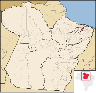
Igarapé-Açu
Municipality in Pará, Brazil
Aktuelle Ortszeit
03:49:48 AM
Wednesday, April 29, 2026
Zeitzone
America/Belem
America/Belem · UTC
Nächster Feiertag
Labour Day
Freitag, 1. Mai 2026 · Public
Geschäftsüberschneidung jetzt
0 / 8
Reference markets are overlapping with Igarapé-Açu right now
Nächster Flughafen
BEL
Val de Cans/Júlio Cezar Ribeiro International Airport · 99 km
Indexierte Flughäfen
15
Curated airport references available for Brasilien
Snapshot at render time: 03:49:48 AM on Wednesday, April 29, 2026 in Igarapé-Açu (UTC, America/Belem).
Status
Nighttime
Week Number
Week 18
Day of Year
Day 119
Days Remaining
246
Current weather
26°C, Overcast
Feels like 31°C · Humidity 90% · Wind 5 km/h
Sunrise and sunset
06:05 AM to 06:10 PM
Day length 12h 5m · Solar noon 12:08 PM
Next country holiday
Labour Day
Freitag, 1. Mai 2026 · Public
Tracked countdowns rendered for Igarapé-Açu local time, with sunrise/sunset and DST stats per page.
Apple WWDC 2026
keynoteMontag, 8. Juni 2026
40 days to go
Code with Claude Tokyo 2026
keynoteMittwoch, 10. Juni 2026
42 days to go
FIFA World Cup 2026 Opening Match
sportsDonnerstag, 11. Juni 2026
43 days to go
Olivia Rodrigo - You Seem Pretty Sad for a Girl So in Love
release-albumFreitag, 12. Juni 2026
44 days to go
UFC Freedom 250 at the White House
cultureSonntag, 14. Juni 2026
46 days to go
G7 Évian Summit
politicalMontag, 15. Juni 2026
47 days to go
Population
35.8K
Coordinates
-1.13, -47.62
Timezone
America/Belem
Indexierte Flughäfen
15
Capital
Brasília
Languages
Portuguese
Currency
BRL (R$)
Country area
8,515,767 km²
Igarapé-Açu (rank #1035 by population in this dataset) sits at America/Belem (America/Belem) with roughly 35.8K residents, anchoring local-time questions for Brasilien.
Igarapé-Açu sits at 1.13°S, 47.62°W; that's the deep tropics (Equatorial Hemisphere, ~125 km from the equator) and the daylight pattern reflects year-round daylight that barely shifts between seasons.
Today the sun rises around 06:05 AM and sets around 06:10 PM in Igarapé-Açu — about 12h 5m of daylight. Brasilien stays on standard time here, so UTC is stable through the year.
Santa Maria do Pará (25 km from Igarapé-Açu) gives this page its nearest commuter and travel cluster, with 15 curated airport pages indexed for Brasilien.
Next country-wide schedule signal: Labour Day on 2026-05-01, useful for handoff and coverage planning around Igarapé-Açu.
Wednesday, April 29, 2026
Timezone
IANA Zone
America/Belem
UTC Offset
UTC
DST Status
Standard Time
Week Number
Week 18
Day of Year
Day 119
Days Remaining
246
Quarter
Q2
Other cities in this timezone
London
+4h
New York
-1h
Los Angeles
-4h
Dubai
+7h
Singapore
+11h
Tokyo
+12h
Sydney
+13h
São Paulo
+0h
Year-long daylight curve. Shows how dramatic high-latitude summers are.
Shows whether it's currently business hours (9am to 5pm) in major financial centers, and how many hours they overlap with Igarapé-Açu.
Igarapé-Açu is a municipality in the state of Pará in the Northern region of Brazil. The population of the municipality is approximately 39,023 inhabitants according to an IBGE estimate in 2020.
Reading Igarapé-Açu against the global hubs: São Paulo (~2,495 km), New York (~5,364 km), London (~7,351 km) are the close ones, with Singapore (~16,840 km) sitting on the opposite side of the planet — a good gut check when judging logistics windows.
Igarapé-Açu sits inside Brasilien — the South America subregion, capital Brasília, languages Portuguese, currency BRL (R$).
The closest mapped neighbors of Igarapé-Açu are Santa Maria do Pará (25 km), Castanhal (39 km), Maracanã (44 km), Marapanim (47 km), so commuter, logistics and same-day-trip planning will usually pull from this cluster.
Upcoming country holiday signals around Igarapé-Açu: Labour Day, Corpus Christi, Constitutionalist Revolution of 1932. Bake those into launch, on-call, and travel windows for Brasilien.
Closest curated airport references from Igarapé-Açu: BEL Belém (99 km), FOR Fortaleza (1052 km), MAO Manaus (1397 km).
Brazil is not one simple clock story, and pages should explain the spread between Brasília time and western states.
Val de Cans/Júlio Cezar Ribeiro International AirportBEL
Belém · 99 km from Igarapé-Açu
Approx. transfer or flight-planning window: 53m
Pinto Martins International AirportFOR
Fortaleza · 1052 km from Igarapé-Açu
Approx. transfer or flight-planning window: 2h 6m
Eduardo Gomes International AirportMAO
Manaus · 1397 km from Igarapé-Açu
Approx. transfer or flight-planning window: 2h 32m
Zumbi dos Palmares International AirportMCZ
Maceió · 1606 km from Igarapé-Açu
Approx. transfer or flight-planning window: 2h 49m
Recife/Guararapes - Gilberto Freyre International AirportREC
Recife · 1607 km from Igarapé-Açu
Approx. transfer or flight-planning window: 2h 49m
Exchange snapshot
Currency snapshot unavailable
On this day
No historical event snapshot is currently available for this date.
Coordination pulse
0 of 8 reference markets are in live business-hour overlap now
| City | Current local time | Difference | Business-hours overlap |
|---|---|---|---|
| London | 07:49 AM | +4h | Check the overlap widget below |
| New York | 02:49 AM | -1h | Check the overlap widget below |
| Los Angeles | 11:49 PM | -4h | Check the overlap widget below |
| Dubai | 10:49 AM | +7h | Check the overlap widget below |
| Singapore | 02:49 PM | +11h | Check the overlap widget below |
| Tokyo | 03:49 PM | +12h | Check the overlap widget below |
| Sydney | 04:49 PM | +13h | Check the overlap widget below |
| São Paulo | 03:49 AM | +0h | Check the overlap widget below |
Val de Cans/Júlio Cezar Ribeiro International AirportBEL
Belém · 99 km away
Pinto Martins International AirportFOR
Fortaleza · 1052 km away
Eduardo Gomes International AirportMAO
Manaus · 1397 km away
Zumbi dos Palmares International AirportMCZ
Maceió · 1606 km away
Recife/Guararapes - Gilberto Freyre International AirportREC
Recife · 1607 km away
Santa Maria do Pará
Brasilien
Approx. 25 km away
Castanhal
Brasilien
Approx. 39 km away
Maracanã
Brasilien
Approx. 44 km away
Marapanim
Brasilien
Approx. 47 km away
Capanema
Brasilien
Approx. 49 km away
Curuçá
Brasilien
Approx. 51 km away
Santo Antônio do Tauá
Brasilien
Approx. 57 km away
São Miguel do Guamá
Brasilien
Approx. 57 km away
Igarapé-Açu liegt in der Zeitzone America/Belem (), mit einem UTC-Versatz von .
Igarapé-Açu beachtet derzeit nicht die Sommerzeit.
Der aktuelle UTC-Versatz für Igarapé-Açu ist UTC.
Igarapé-Açu sits at 1.13°S, 47.62°W in Brasilien, with about 35.8K residents (rank #1035 by population in this dataset).
The closest reference hub to Igarapé-Açu is São Paulo, about 2,495 km away as the crow flies.
Santa Maria do Pará is the closest indexed city, roughly 25 km from Igarapé-Açu.
Val de Cans/Júlio Cezar Ribeiro International Airport (BEL) is the closest curated airport reference, about 99 km from Igarapé-Açu.
Labour Day is the next upcoming holiday in Brasilien, on Freitag, 1. Mai 2026.

